



You've found the Picture the Stars star map, our best-selling product, and now you're wondering: are star maps accurate, and how do they actually work?
Star maps are far older than we are. People have charted the sky for thousands of years to navigate, farm and keep time; the oldest complete star atlas known, the Dunhuang Star Chart, was drawn in China around 700 AD and is now kept at the British Library. Those early charts were drawn by hand from what people could see. Today's maps are calculated from star positions measured by satellite, which is what makes a modern star map accurate to your exact night.
Yes, a Picture the Stars star map is accurate. We calculate every map from your date, time and exact location, using star positions from the Hipparcos catalogue and other star databases. The stars and constellations are drawn exactly where they were for your date, time and place.
How can a printed star map be accurate at all?
Because the sky is predictable. Astronomers have measured the positions and movements of the stars for centuries, and the Earth spins and orbits in a way that can be calculated to the second.
To calculate the stars for your moment, we need just three things from you: the date, the time and the place. From those, our software works out exactly which way the Earth was facing and which stars were above your horizon, then draws your map. You can watch it happen in real time in our online star map builder.
That's why a map for 1975 is as accurate as one for today.
What actually goes into a Picture the Stars map?
Here is what happens behind our online builder when you create your star map:
- Your location becomes coordinates. The town, venue or postcode you type is found with Google Maps and turned into exact latitude and longitude.
- Your time sets the rotation. The sky turns 0.2507 degrees every minute, or 15.041 degrees an hour: one full turn every 23 hours, 56 minutes and 4.09 seconds, as the Earth spins against the stars. If you don't know the time, leave it blank and we use midnight.
- Star positions come from Hipparcos, and more. Hipparcos is the European Space Agency catalogue, measured by satellite, that astronomers still use for the bright stars. We combine it with other sources to enhance the detail of your sky, and add the Milky Way on top, matched to the same sky.
- We correct for the Earth’s wobble. Star catalogues record each star’s position precisely, but the sky you see also depends on the Earth’s point of view: which way it is facing and how it is tilted. The Earth’s axis wobbles slowly, like a spinning top, turning the whole sky by one degree about every 72 years. Astronomers call it precession. Catalogue coordinates use a reference date and coordinate system, so calculating the sky for another date requires allowing for the change in the Earth’s orientation. We don’t rely on the catalogue alone: every map sets the Earth exactly as it was facing on your date, so the stars sit where they really were.
- We correct for the Earth’s nod. On top of the slow wobble, the Moon’s pull makes the Earth’s axis nod slightly over an 18.6-year cycle. Astronomers call it nutation. Every map allows for that too. Both corrections are explained in full on our science page.
We print thousands of stars, choosing a brightness limit to suit each print size. This includes the familiar stars visible to the naked eye and some fainter ones; what you can see outdoors depends on the darkness of the sky and your eyesight. Brighter stars get bigger dots. Drawing every star in the catalogue would crowd the print.
How do we check every map?
- The sky is calculated from catalogue data. The print engine uses the chosen date, time and coordinates to place the stars. You can compare the constellations with an independent astronomy program using the same details.
- A person checks your file before it prints. Somebody opens it and checks your sky, your text and the print quality. A human, not an automated check.
- A second check after printing. The finished print is looked over again under a daylight lamp before it is packed.
Our how our star maps work page explains the catalogue data, coordinate calculations and print resolution.
Your date, time and place determine the sky shown on the map. Print size determines how much detail fits on the paper. To check the broad pattern, compare the constellations with an independent astronomy program using the same details.
These illustrations show a 60x80 print and an enlarged area around Orion.
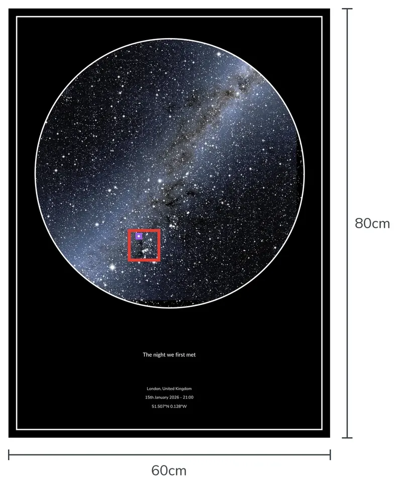
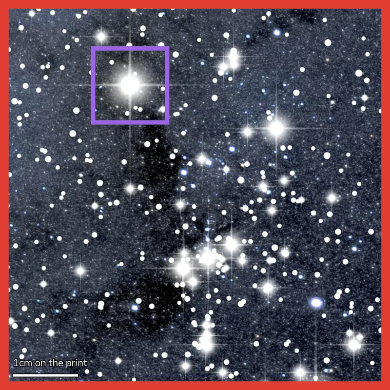
Our science page explains how the stars are chosen: “those stars which are brightest and most visible to the naked eye are always printed”, and larger prints show more. Every step from file to dispatch is on our how we print page.
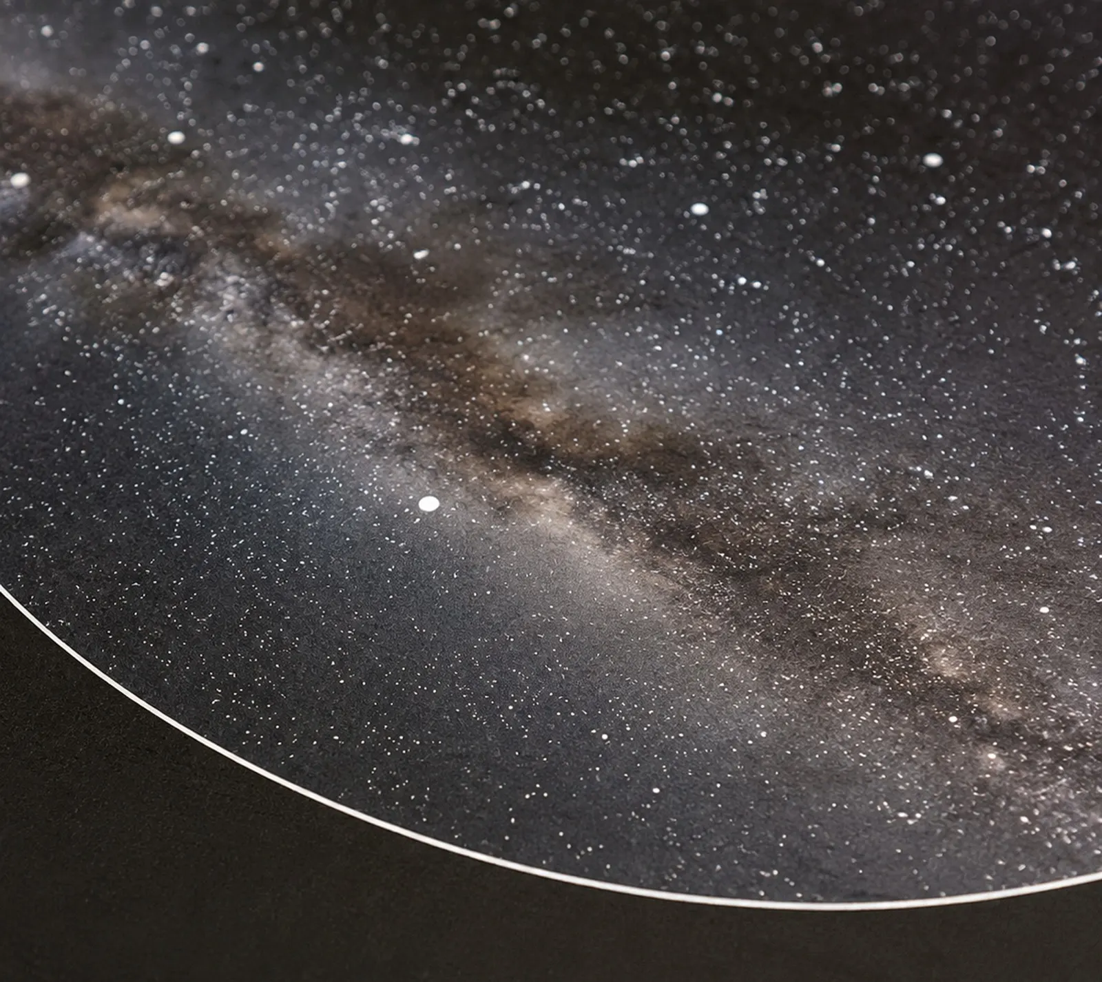
A close-up of one of our printed star maps. Bigger dots are brighter stars.
What affects the detail you see?
A few things shape what a star map, or an astronomy program, can show:
- The air bends starlight. Before it reaches your eyes, starlight passes through the atmosphere, which bends it like a lens. Near the horizon it lifts a star by up to about half a degree; overhead the effect almost disappears. How much it bends changes with the temperature and air pressure on the night, so the sky you actually saw was never quite the same as any calculated map.
- Your time sets the limit. The sky turns a quarter of a degree every minute. If the time on your map is a minute out, the whole sky is a quarter of a degree out, which is why the exact time matters more than anything else.
- Image resolution gives a useful scale. Our final print images are rendered at about 300 pixels per inch, so one image pixel spans about 0.085mm on the paper. An image pixel is not the same as an ink dot: the printer uses a finer grid of ink droplets.
A star map calculates the stars’ positions for your date, time and place. The result is a chart of the sky, rather than a photograph of the weather and viewing conditions that night.
Is it your real sky, or just decoration?
Ours are both. The stars are calculated to show the true sky for your date, time and place. Then we design the print around them, balancing the number of stars, the detail, and the brightness of the Milky Way, so the sky is both accurate and beautiful on the wall.
We know what our customers want: something to hang on the wall and give as a personal, thoughtful gift, not a technical chart for navigating the seven seas, which is what star maps were first made for.
You can see the difference yourself. Change the time in our live preview from 9pm to 3am and the whole sky turns, with new constellations rising over the edge. On a decorative print, only the words would change.
What about the Watercolour star map?
Our Watercolour theme bends the rules on purpose. Behind the stars sits an artistic layer depicting the cosmos: a painted sky created by a digital artist, matched to the Milky Way and covering the whole sky underneath the stars.
The stars themselves are still calculated exactly for your date, time and place, as on every one of our maps. Only the colour behind them is art. For full astronomical accuracy we recommend Real Photo or Original Black; for a colourful, artistic map, choose Watercolour.
What will an accurate star map show, and not show?
Worth knowing before you order, because it catches people out.
Our star maps show:
- The stars above your horizon at that moment, in their true positions.
- Brighter stars as bigger dots, so the sky looks as it would to your eye.
- The constellations, with optional lines and names to pick them out.
- The Milky Way running across your sky.
They do not show:
- The weather. Clouds, rain and city glow are not on the print. You get the clear sky that was above them at that moment, whatever the weather was doing.
- A telescope view. It is the whole sky as you would see it lying on your back, not a close-up of a galaxy. Our guide on how to read a star map explains why: the centre is the point straight above you and the edge is the horizon all the way round.
- Every faint star in the catalogue. We limit the number of stars to keep the map readable. Larger prints include fainter stars, reaching magnitude 7.3 on a 60x80 print, beyond the usual naked-eye limit.
- Your surroundings. Trees, buildings and hills are left off. The edge of the circle is a clean horizon all the way round.
- Daylight. A map for the middle of the day shows the stars that were there behind the blue sky, as if the Sun had stepped aside.
- Passing things. Aeroplanes, satellites and shooting stars come and go in seconds, so they are not on the print.
How can you check a star map yourself in 60 seconds?
You don't have to take our word for it. Here's the test we give customers who are still curious:
- Open Stellarium, a free, independent astronomy app. It runs in a browser at stellarium-web.org.
- Enter the same date, time and place as your map.
- Look straight up, then compare the big shapes. The Plough, Orion, Cassiopeia, whatever is overhead that night.
Know the time? Add it. The sky turns 15 degrees every hour, so even a rough time, like just after 8pm, gets you much closer to the real sky of your moment than the midnight default.
Frequently asked questions
Are star maps accurate for dates in the past?
Yes. The movement of the Earth is predictable enough to calculate the sky for any date in living memory, and far beyond. A map for a wedding in 1975 is worked out the same way as one for today.
Can I order a star map for a future date?
Yes. The same maths runs forwards. People order maps for weddings, due dates and anniversaries that have not happened yet, and the sky on the print will match the real sky on the night.
What time do you use if I don't know the exact time?
If you leave the time blank, the map is worked out for midnight at the start of your date. If you know the real time, add it. An hour makes a visible difference, because the sky turns 15.041 degrees every hour.
Does bad weather or light pollution change the map?
No. A star map shows where the stars were, not what you could see through the clouds. If it poured on your wedding night, your print still shows the clear sky above the rain, exactly as it was.
Why does my star map look like my friend's?
Because two nights from the same country share most of the same stars. The differences are in which constellations sit highest and which have risen or set. We explain it fully in our guide to why star maps look similar.
See the real sky from your moment
Every Picture the Stars map is calculated for your date, time and place, checked by a person, and printed in our Failsworth workshop in Manchester, as we have done since 2018. Type in your moment and the live builder draws your sky in seconds. Which moment would you capture in the stars?
Prints start at £21.99, printed on 285gsm museum-grade art cardstock, with free UK delivery. And we're rated Excellent on Trustpilot.
Curious why two dates can look alike? Read why star maps for different dates look so similar, or learn how to read a star map. When you're ready, build a free live preview of your star map. It takes about 30 seconds and there's nothing to pay until you order.
See the specific sky above your own moment. Free live preview.
Build Your Star Map